Where Is Huatulco Located? Map, Distance & Travel Guide
Where Is Huatulco Located? Map, Distance & Travel Guide
Huatulco is on the Pacific coast of Oaxaca, Mexico, about 70 km (43 miles) southeast of Puerto Escondido along Federal Highway 200. Its full name is Bahías de Huatulco — nine bays and 36 beaches spread across roughly 35 km of coastline inside the Huatulco National Park, with the international airport (HUX) serving as the region’s main gateway.
| From | Distance | Travel Time | How to Get There |
|---|---|---|---|
| Puerto Escondido | ~70 km / 43 mi | ~1.5 hrs | Car, bus, or colectivo on Hwy 200 |
| Oaxaca City | ~275 km / 171 mi | ~5.5–6 hrs by road / 40 min flight | Rental car, ADO bus, or flight to HUX |
| Salina Cruz | ~110 km / 68 mi | ~2 hrs | Car or bus via Hwy 200 |
| Mexico City | ~570 km / 354 mi (air) | ~1 hr 40 min flight | Direct flight to Huatulco Intl. Airport (HUX) |
Distances are approximate road/flight distances as of 2026. Coordinates: roughly 15.77° N, 96.13° W.

Where Exactly Is Huatulco Located?

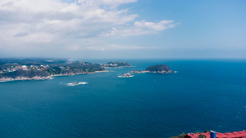
“Huatulco” is shorthand for the municipality of Santa María Huatulco, which sits on the southern Pacific coast of the Mexican state of Oaxaca — part of the region locals call “La Costa,” the same stretch that includes Puerto Escondido, Mazunte, and Zipolite further northwest. Unlike Puerto Escondido’s single long beach, Huatulco is built around nine distinct bays — Santa Cruz, Chahué, Tangolunda, and six others reachable mostly by boat — protected within the federally managed Huatulco National Park.
Three towns make up the visitor-facing area: Santa Cruz Huatulco (the original fishing port and marina, now with a cruise terminal), La Crucecita (the inland town center with the main plaza, restaurants, and hotels), and Tangolunda (the resort and golf-course zone). All three sit within a 10-minute drive of each other and of the airport.
How Far Is Huatulco From Puerto Escondido and Other Cities?
- From Puerto Escondido: ~70 km southeast on Federal Highway 200 — about 1.5 hours by private car, roughly 2 hours by second-class bus with stops.
- From Oaxaca City: ~275 km over the Sierra Sur mountains — a long but scenic 5.5–6 hour drive, or a 40-minute domestic flight into HUX.
- From Salina Cruz / the Isthmus: ~110 km east along the same coastal highway, about 2 hours by car.
- From Mexico City: no practical road option for most travelers — direct flights to Huatulco International Airport (HUX) run about 1 hour 40 minutes.
What Makes Huatulco’s Location Special?

Huatulco’s location is what sets it apart from its more bohemian neighbor Puerto Escondido. The bay-and-headland geography creates calmer, more swimmable water than Zicatela’s famous surf break, and roughly 70% of the surrounding land is protected national park, which has kept development concentrated in three planned towns rather than sprawling along the coast.
That same geography also makes Huatulco a natural base for boat-based day trips — snorkeling at Playa La Entrega, beach-hopping between otherwise inaccessible bays, and short crossings to nearby Mazunte and the wider Oaxacan coast that aren’t as easy to do from a single fixed beach.
Getting to Huatulco: Airports and Routes
- By air: Huatulco International Airport (HUX) sits about 15 minutes from Tangolunda and La Crucecita, with direct flights from Mexico City, Oaxaca City, and seasonal U.S./Canada routes.
- By road from Puerto Escondido: Federal Highway 200 runs the entire coastal stretch; buses (including ADO) and shared colectivo vans make the ~1.5–2 hour run several times a day.
- By road from Oaxaca City: Highway 175 or 131 crosses the Sierra Sur before joining Highway 200 near the coast — a spectacular but winding drive best done in daylight.

FAQ: Huatulco’s Location
What state is Huatulco in?
Huatulco is in the state of Oaxaca, Mexico, on the Pacific coast — in the municipality officially named Santa María Huatulco.
Is Huatulco close to Puerto Escondido?
Yes. Huatulco is about 70 km (43 miles) southeast of Puerto Escondido, roughly 1.5 hours by car or bus along Federal Highway 200 — a common day-trip or stopover distance for travelers combining both destinations.
Does Huatulco have its own airport?
Yes, Huatulco International Airport (code HUX) sits a short drive from Tangolunda, Santa Cruz, and La Crucecita, with direct flights from Mexico City and Oaxaca City plus seasonal international routes.
How long does it take to drive from Oaxaca City to Huatulco?
About 5.5 to 6 hours by car over the Sierra Sur mountains, or roughly 40 minutes by direct flight into HUX — most travelers on a tight schedule choose the flight.
Planning to see both sides of this stretch of coast? Read more about the wider Bahías de Huatulco region, or check our guide to things to do in Puerto Escondido before you decide how to split your trip between the two.
auto_awesomeContinue exploring Puerto Escondido
You Might Also Like
 articleAdventurescalendar_todayJan 6, 2026
Best Day Trips from Puerto Escondido: Explore Oaxaca’s Hidden Coastal Treasures
Puerto Escondido is more than just world-class surf and stunning sunsets—it’s your gateway to some of Oaxaca’s most brea
 calendar_todayAug 31, 2026
Laguna de Chacahua: The Complete Guide to Oaxaca's Crocodile Lagoon
A complete guide to Laguna de Chacahua's crocodile-filled lagoon, mangrove boat tours, and the bioluminescent beach beyo
 calendar_todayAug 30, 2026
Things to Do in Zipolite, Oaxaca: Beaches, Surf & Sunsets
From Playa del Amor to the nightly mezcal-and-sunset ritual: a local's guide to filling your days in Zipolite, Oaxaca.